
|
Nuweiba Beach Debunked |
|
Page 9 |
|
The Nuweiba Beach yarn. This was invented by Ron Wyatt, an amateur archeologist, who made up a story about finding the remains of Pharaoh's army on the sea floor off the Egyptian beach resort of Nuweiba Beach Egypt. He did point to the mountain Jebel al-Lawz as Mount Sinai. But, in that case even a blind squirrel can find an acorn or two. There are a number of authors who dreamed up someway to explain this. The speed of travel and locations of camps vary among them. Here is a list of the problems with these allegations. 1. The Wilderness of Shur has to be moved to where Marah is. In this case it has to be moved to Midian. The desert of Etham goes along with this. So it too has to go to Midian. |
|
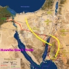
A mock up of what a Nuweiba Beach route might look like. |
|
The Wilderness of Sin is not generally known but it probably is centered on Hashem El Tarif. This desert has to move to Midian as well. 2. The Etham camp has to go to somewhere east of Hashem El Tarif along the road from Suez to Eilat. This supposedly is at the edge of the desert. But, in this case the hoaxers say it would be at the far edge. I guess the actual edge would be the Gulf of Aqaba. How does someone know where the far edge would be 30 miles from coming to the end? 3. The time of travel varies depending which author is presenting their theory. In most cases the speeds are incredible. I cover the march times on page 86. But, the Israelites travel at their slowest element. In this case the slowest element is the ox-cart. There were a few ox-carts used. These move at 2 miles an hour at 10-15 miles a day on roads. Like most elements they move at reduced speed if they have to go through the desert or in wadis. Oxen have to rest after 8 hours and cannot go 24 hours straight if indeed any one can. One also has to wonder what kinds of physics allows the Israelites to travel 30-50 miles a day before they reach Nuweiba Beach but once they cross over to Midian their speed drops to only 6-10 miles between camps? 4. Moses tells the Israelites Ex. 14:1 Then the Lord said to Moses, "Tell the Israelites to turn back [shub] and encamp near Pi Hahiroth, between Migdol and the sea. They are to encamp by the sea, directly opposite Baal Zephon.". If they are told turn back that doesn't mean to turn to the right and go south and up Wadi Abu Buthayran then cross the continental divide and then go down the rough Wadi Watir. They don't know where these places are. They are told to go to Pi Hahiroth and Migdol. They must know where they are or they wouldn't have been commanded to go there. Those places aren't at the end of a narrow wadi they have never seen before. According to Dr. David Rohl Pi Hahiroth is the house at the mouth of the canal. That is the town at the mouth of the canal. No evidence of a town existed on Nuweiba Beach. Scripture also says that Pharaoh thinks they are hemmed in by the desert. The Etham camp is on the road to Ezion-Geber so there is no hemming in there. So maybe the hemming in occurs at the beach. This is not true because the Israelites could escape up or down the coast so are not hemmed in. Furthermore how would the Pharaoh know the situation of the Israelites? Especially, if the Egyptians cannot get past the cloud blocking the wadi. Thus Moses has to lie again. Wyatt's theory has to spindle scripture to get it to harmonize with facts. 5. No relics have been found at the bottom of the Red Sea to verify the Pharaoh's army lying there. Nuweiba Beach is a resort where facilities allow people to skin dive. Thousands of divers have been over the area were the supposed chariots and bodies of Egyptian soldiers would of rested. Apparently none have come up with golden chariot wheels or any other relics. So unless they all have been taken as souvenirs without Egyptian authorities being aware or there were none to be found. His excuse that his dog ate the golden chariot wheel doesn't hunt. 6. Now the theory also says that the Sinai to the west of the Gulf of Aqaba was Egypt. This means Ex 16:3 on the fifteenth day of the second month after they had come out of Egypt. So they reach Elim on the 31st day after crossing. Because it doesn't say 31st day after Passover, it says after leaving Egypt. That's a lot time to mill about and get to al-Lawz which is about 45 straight line miles from Nuweiba Beach. 7. Exodus 15:22 Then Moses led Israel from the Red Sea and they went into the Desert of Shur. For three days they traveled in the desert without finding water. So the desert of Shur is in Midian contrary to all other geography. My question to prove that Shur has to be west of the Negev desert. Genesis 20:1 Now Abraham moved on from there into the region of the Negev and lived between Kadesh and Shur. For a while he stayed in Gerar, No matter where you locate Kadesh, either at Ein Qudierat or Petra Shur will be next to the Negev desert not in Midian. Numbers 33:8 They left Pi Hahiroth and passed through the sea into the desert, and when they had traveled for three days in the Desert of Etham, they camped at Marah. So the desert of Etham is also in Midian. But I thought the Etham camp was at the far edge of the Etham desert? Apparently not so much. Thus Moses lied about that. Or someone can't read scripture. And three days of travelling at the rate of march that was used to get to Marah should be about 90 miles. Thus they went past al-Lawz by 45 miles or they are going in circles. David Rolh asked the question about Genesis 16:14 That Hagar the slave girl fled Abram's house in the Negev and was found at a well at Be'er Lahai Roi which is between Shur and Kadesh. The answer was to move Be'er Lahai Roi to somewhere 10 miles south of Mt. Rumm in Jordan. This quite a trek for someone alone on foot. Funny thing after Abraham's death Isaac moved to Be'er Lahai Roi, However, Genesis 26:5 says Isaac lived in Gerar. In the following narrative Isaac only moves around the area near Gerar and Beer-shiva. 8. Some oasis has to be found that will be claimed to be Elim. While the road to al Bad' is the Darb al Hajj where millions of Muslim pilgrims traveled for centuries to Mecca and the Sultans built oasis after oasis for the pilgrims it will be claimed one oasis is Elim. 9. Next the theory has to make the children of Israel go to the sea shore again in the Desert of Sin. Here the manna or the quail have to appear depending on how they spin it. 10. Then there are a series of other camps. Probably each less than 10 miles apart that will wind their way to the backside of al-Lawz. Yep 10 miles between camps when in the Sinai the Israelites were going at 30 miles a day and two camp over 170 miles apart. The logic is appalling. 11. Dr. David Rolh's arguments against Nuweiba Beach. PDF Apparently the theory assumes a 7 day travel time. My correction to his point (7) calculation. Use the Distance Calculating tool Distance.to. Link I calculated the road milage from Tell ed-Daba/Avaris to Nuweiba (going by way of Mitla pass) and it comes to 303 miles (43 miles a day) . If using the Wadi Sedr pass it is 355 miles (51 miles a day). It is likely the Mitla Pass short cut didn't exist until Roman times or even the 15th Century. As mentioned previously Egyptian armies averaged 15 miles a day. Thus they would take 24 days to reach Nuweiba beach camp. Making a total of 31 days. Thus the manna and the quail will all be there at the Numbers 33:10 Red Sea camp. 12. Some other debunkers state that Horeb isn't in Midian because both Jethro and Hobab are at Horeb with Moses and the Israelites at one time or another and each states they are leaving and going back to their home, kinsmen or country. This supposedly proves that Horeb is not in Midian. There are some holes in this reasoning. Midian isn't a country with proper borders and a ruler. It is an area with many clans of spread out Bedouins. Jethro and Hobab's home may not be at al Bad' or somewhere near Horeb but some other village in Midian like Qurayyah. They could of traveled to Horeb to be with Moses and family. They could of moved to al Bad' at some time after the second year. They also could live at al Bad' and just be saying they are going back home and leaving the camp. BTW, Qurayyah satisfies one translation of Exodus 3 Now Moses was tending the flock of Jethro his father-in-law, the priest of Midian, and he led the flock to the far side of the wilderness and came to Horeb, the mountain of God. Where 'the far side' is translated as the 'west side' of the wilderness as al Lawz is through the wilderness to the west of Qurayyah. |
|
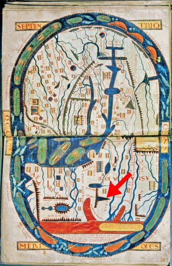
Dr. Hoffmeier introduced the c. 1050 A.D. Saint Sever Beatus map at the left as proof that Mt. Sinai is in the Sinai Peninsula saying that the red arm on the left is the Gulf of Suez and the right arm is the Gulf of Aqaba. But that is incorrect as the Gulf of Aqaba doesn't have two large rivers entering it along its sides. That is the Persian Gulf. The peninsula has to be the Arabian Peninsula with the Red Sea as the left arm. That would put Mount Sinai at the northwest corner of the Arabian Peninsula (arrow). The Arabian Sea is colored red at the bottom. |