
|
The Exodus |
|
Other Maps and Theories One problem I don't have is misplacing Kadesh or Kadesh-Barnea. There is a modern Kadesh Barnea near the Brook of Egypt in south-west Israel. I believe this is the wrong place for Moses' Kadesh which would be Petra. DT 2:14 Thirty-eight years passed from the time we left Kadesh Barnea until we crossed the Zered Valley. (Also, note they did not spend all this time in Kadesh,) Nu 13:26 They came back to Moses and Aaron and the whole Israelite community at Kadesh in the Desert of Paran. Nu 20:1 In the first month the whole Israelite community arrived at the Desert of Zin, and they stayed at Kadesh. There Miriam died and was buried. Nu 33:36 They left Ezion Geber and camped at Kadesh, in the Desert of Zin. Kadesh is described as being in the Desert of Zin and in the Desert of Paran. That is because it sits right between them. Present day incorrectly located Karesh Barnea would be in the middle of the Desert of Zin. Nu 20:14 Moses sent messengers from Kadesh to the king of Edom, Nu 20:16 Now we are here at Kadesh, a town on the edge of your territory. (Edom) So Kadesh is at the southern border of Edom. Edom is far to the east of modern Karesh Barnea. If Edom was on the border of modern Kadesh Barnes the Israelites would have to travel through Edom to get to Kadesh Barnes from Ezion Geber. Numbers 34:3 Your southern side will include some of the Desert of Zin along the border of Edom. Your southern boundary will start in the east from the southern end of the Dead Sea, 4 cross south of Scorpion Pass, continue on to Zin and go south of Kadesh Barnea. If you look where the present Kadesh Barnea is it is almost due west of the southern end of the Dead Sea. But, Petra fits perfectly. The misplacement of Kadesh Barnea as well as that of the Mt. Sinai mountain was the prime reason the Exodus path on maps were wrong. Those maps placed cities on the map in Numbers 33 order. Often only a few miles apart. They had the Red Sea crossing as some place on the coast of the Gulf of Suez or the Great Bitter Lake. Here is someone who is adamant that Kadesh is Petra and the other one is fake and proves it. Kadesh means holy and there are altars for many different pagan gods there. Lately, map makers are better informed and accept that the Mt. Sinai in the Bible is Jabel Lawz. But, they still want the Red Sea Gulf of Aqaba crossed in the dramatic fashion of the Hollywood movies. So, Moses has to lead the Israelites along the coast of the Sinai to a place where a dramatic crossing can be made. They choose some place where the sea is 2,500 feet deep. If God is going to power a parting of the sea what difference does the depth matter? It might as well be 1000 feet deep if God is going to do it. So one question I would ask is if Moses and Aaron had made the trip between Goshen and Midian several times before why would they choose a risky path they've never seen before? Plus if they are going to walk all the way across the Sinai to the west shore of the Gulf of Aqaba why not just walk a few miles more to get to the east shore? To make the map match Numbers 33 order only a few camp sites are placed before the crossing. Then in Midian the remaining camp sites on the list show the Israelites mill about aimlessly marking all Numbers 33 sites until they finally get to Mt. al-Lawz. Still there is the math. One author advocates that the Israelites crossed the Red Sea at Nuweibaa beach. At least 355 miles from Pi-Rameses (Avaris : 30.787, 31.821). Another has the crossing at the shore at the Straits of Tiran some 330 miles from Pi-Rameses. Exodus 13:2 Tell the Israelites to turn back and encamp near Pi Hahiroth, between Migdol and the sea. They are to encamp by the sea, directly opposite Baal Zephon. 3 Pharaoh will think, 'The Israelites are wandering around the land in confusion, hemmed in by the desert.' 4 And I will harden Pharaoh's heart, and he will pursue them. Exodus 13:6 So he had his chariot made ready and took his army with him. Israelites first turn back and then encamp before Pharaoh finds out, gets ready and starts his attack. So information had to somehow get to Pharaoh in short enough time that they are still in their camp before he starts. How is Pharaoh going to know were the Israelites are camped or turned back 355 miles away? In the timeline the Israelites have to get to the camp next to the sea before Pharaoh even starts. Exodus 13:9 The Egyptians--all Pharaoh's horses and chariots, horsemen and troops--pursued the Israelites and overtook them as they camped by the sea near Pi Hahiroth, opposite Baal Zephon. Baal Zephron means Lord of the North. Baal is a Philistine god, There are no Philistines operating in the Red Sea. In a southern sea is not north of anything. It was also revealed that the Israelite army crossed the Red Sea into the Desert of Shur. There is no Desert of Shur in Saudi Arabia. We have also supposed movement rate of Egyptian armies. Thutmose III mobilized his forces and marching from Thebes toward Megiddo in 1457 BC. The army crossed the border of Egypt and crossed 138 road miles to Gaza in just over 9 days and rested. This is about 14.5 miles a day. I can't believe that the chariots would be able to make the journey to the south end of the Sinai Peninsula without a logistical supply chain. To illustrate the difficulty of supplying horses with water and fodder on such a mission the British and ANZAC cavalry in the Sinai of 1916 is an example. In World War I the British were at war with the Turks in Egypt and the Middle East. The Turks allied with the Germans attempted to invade Egypt and sever the Suez Canal supply line. This was turned back at the canal and the British drove those forces back toward Palestine. British forces consisted of horse cavalry and camel forces. Excerpt from AUSTRALIAN IMPERIAL FORCE IN SINAI AND PALESTINE by H.S. GULLETT: The British evaluate the Sinai. My parenthesis. Winding tortuously through the steep mountainous desolation of the south run the paths from Akaba (Aqaba) to Suez (Way of the Wilderness), either by Nekhl (Elim) or by a track further south (Way of the Heights). By this |
|
route Moses passed with his great host in the long-drawn Wandering, avoiding as a military necessity the easier approaches to Palestine further to the north. The Turks passed small bodies of troops over these tracks in the earlier stages of the war; and, as the British operations in Sinai developed, Australian forces from the Imperial Camel Brigade rode twice to Akaba to make touch with the Arabs of the Hejaz (Midian). The route was easily passable for camels, but impracticable for wheels, and therefore useless for an army equipped with modern artillery. Pg 44 In 1915 the Turks invaded Egypt going by the Central route (Way of the Shur) with 7,000-11,000 men. There was enough water to supply this amount. It took 10 days to march across the Sinai, traveling mainly by night. Sinai map link This is 185 miles thus the rate of march is 18.5 mp day better than Moses's 14-15 miles per day travel speed of Mt. Sinai to Kadesh-Barnea. 3,000 troops traveled both the coastal road and the southern road but the times are not known. At best this central road across Sinai was hazardous. The water-supply, if properly developed, might maintain a small army during a rapid march; but it was so limited that, if the army was checked, it could not stand its ground, but must retreat at once to the surer spring supplies of southern Palestine by the road it had come. Pg 46 To those not familiar with the use of cavalry in |
|
Page 6 |
|
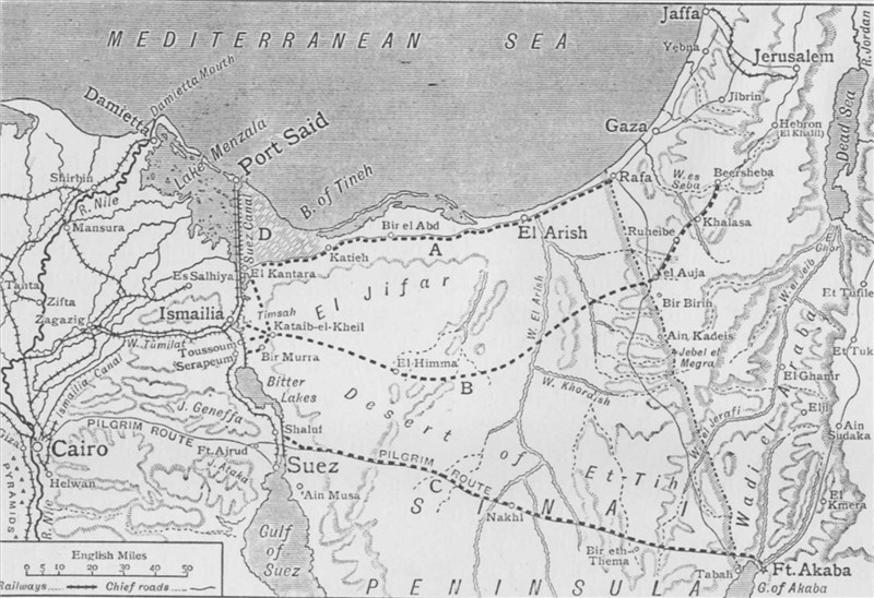
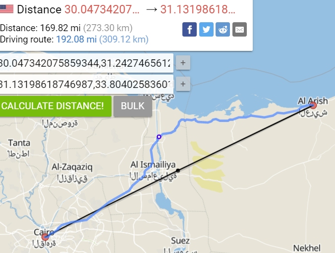
desert campaigning the numbers may seem amazing. A mounted brigade in Sinai and Palestine seldom put more than 800 rifles into the dismounted firing line, while an infantry brigade at full strength fights about 3,500 men. But the supplies for a cavalry brigade are greatly in excess of those needed by a brigade of foot. The day's ration for a man weighs only two or three pounds, while that for a horse weighs twenty pounds, and horsefeed is very bulky. Moreover the use of horses in a dry country imposes a heavy task upon those responsible for the supply of water. The daily desert ration of water for a man was at most one gallon; frequently it was cut down to a quart, and at times to a pint. But horses required five gallons; and, although the animals could and often did live on a great deal less, they only did so at the cost of their condition and the rapid decline of their strength and usefulness. It was clear, therefore, that any force moving out into Sinai must be accompanied by a vast transport organization and an abundant water-supply. Pg 49 On the oasis area (Romani) water was freely found at a depth of from two to twelve feet: but the supply was more or less brackish, and the springs which were touched by the roots of the palm trees proved especially bitter. pg 101 Example of cavalry travel times in the Sinai. 1. 8th Light Horse (Victoria) ... Along the Coast the column traversed eighty miles of sheer desert in thirty-seven hours, including halts. Pg 69 2. 9th Light Horse (South Australia and Victoria)… Attacking a small Turkish force at Jifjafa (Marah), a post situated in the Sinai Range at an altitude of about 1,000 feet, some fifty-two [as the crow flies] miles east of the Canal. Taking 35 hours to reach it. Pg 71 Moses brought along several oxen cart teams which have a slow travel rate. Individual oxen and cattle can travel at 2 to 2.5 miles an hour or 16-22 mile a day march rate. Teams at a slightly slower rate. Oxen are strong animals. They have twice the pulling strength as a horse. Documented animal travel speeds British 1908 Reference. PDF The fastest known travel rate in the Sinai by an army before motor transportation was made by Napoleon's army in a forced march going from Cairo to al-Arish in 7 days. This is 192 miles at a rate of 27.4 miles a day. map Then there is logistics. The Egyptian chariots might have been sent out with enough water and food for a 2-3 day foray but for extended operations of four or more days they will need a baggage train to supply them. This is a slow moving caravan that might travel at 9-15 miles a day. They will be hard pressed running down an enemy that probably is moving at the same speed. It would be like one snail chasing another snail. To illustrate the folly of trying to fit the exodus path of travel with a Strait of Tiran crossing. In both these unrealistic theories the Israelites make 9 camps and cross 5 different deserts in the space of 45 miles to get to Mt, Horeb, And they place Etham camp right near where they want to cross the Gulf of Aqaba. That is when the pillar of fire at night and pillar of smoke during the day starts to guide them. Why do they need to be guided then? They can see the mountain right across the water some 40-50 miles away. You have the same problem with what I call the Nutty Nuweibaa Beach scenario. Namely ignoring the lack of camp sites before the leg to the crossing and then jamming all them in for the final 8 encampment crawl to the final site. And then claim a new desert is being crossed every 2-3 sites. Besides the deserts being misplaced what desert are they going to place Kadesh in? These guys say there are chariots and horse bones encrusted in coral in the waters off the beach. They never did produce any for inspection. If they ever dredge some up they would have to be dated to the Egyptian army of Moses time. There was plenty of military equipment sent by ship during Solomon's reign and that of his son. In fact Solomon was an arms dealer who sent chariots and horses to Ophir in trade of gold and other products. Probably a number of these were lost in storms. 1 Kings 22:48 Now Jehoshaphat built a fleet of trading ships to go to Ophir for gold, but they never set sail--they were wrecked at Ezion Geber. Neither Moses nor Aaron had ever traveled to those crossing points before. Plus there are no roads to the crossing points. There is very little water on the way to those points and no water there. Basically, the Israelites would all die before Pharaoh can even get there to save them from Moses' madness. Ex 13:18 So God led the people around by the desert road toward the Red Sea. There are no roads to either of these crossings. God tells Moses to tell the Israelites to turn back at Etham which is at the edge of the desert. Where Ron Wyatt puts Etham there is no edge. Ex 14.2 the children of Israel are told to turn and camp before PPi Hahiroth between Migdol and the sea, before Baal Zephon. If these were all at Nuweiba beach and the children of Israel knew where they were why didn't God just say 'Turn and go to Nuweiba'? I'll mention this again. Exodus 15:22 Then Moses led Israel from the Red Sea and they went into the Desert of Shur. The Shur is the wall or fort line near the fresh water lakes and swamps on Egypt's border. It isn't in Arabia. Where does the Bible say the Wilderness of Shur is? Genesis 20:1 Now Abraham moved on from there into the region of the Negev and lived between Kadesh and Shur. For a while he stayed in Gerar, The Negev is still mostly where it was in Moses's time. Except then it was the northern part of the present day Negev. Gerar has been located and it is between Gaza and Beer Sheba. Now, Kadesh would be on the opposite side of the Negev from Shur. So either it would be near Petra (where I place it) or near Ain el-Qudeirat or Ain Qedeis. But, el-Qudeirant and Qedeis are in the Negev desert near Beer Sheba so they couldn't be between and in something at the same time. Thus Shur would have to be to the west of the Negev. Between Egypt and the Negev. |
