
|
The Exodus |
|
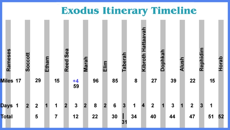
Map 3 Problems Deuteronomy 2:1 Then we turned around, and we traveled on the desert road toward the Red Sea, as the Lord had told me to do. Deuteronomy 2:2 Then the Lord said to me, 3 "You have traveled through these mountains long enough. Turn north. This is the most incredible spot. It goes from year 2 of the journey to year 40 in one verse. It is like a time warp. 38 missing years. There is no narrative of what went on. Not even in Flavius Josephus works is there any information on this black period of time. I have found that several of the location of the Nu 33:17 to Nu 33:35 camp sites are not camp sites at all but are towns given by Jacob to make up Judah. They are to the west of Hebron. Since these would not be Israelite wanderings they must be towns the rogue Israelite army attacked. Another site is Rimmon-Perez which is near Kadesh which was awarded to Judah. Most likely it is somewhere on the route to the other towns. It seems that some towns south of Edon were incorporated into Judah. A couple of other towns or sites may be mines in the Negev Desert. So these location would be subtracted from the wandering sites. So these sites probably should be on map two. Right now I don't know how many are on the abortive attack into Canaan and how many are part of the 38 years of wandering. One thing that may poor cold water on this map may be that all of these are sites of the Israelite army retreat from Canaan to Ezion-Gerber. I added one more speculative site which would be before Ezion Geber. That is Abronah. There are ruins at Wadi Ainounah which is south of Midian on the coast. If that is the Abronah site then the next site would be Jotbathah. I can't find any location that has that root. One other idea is that the list of camps is not a march in one direction or other but a list of places of living for all of the 38 years the Israelites spent waiting for another go to take the promised land. So indeed it could be a circle or a zig-zag wandering in the Jordan-Arabian region. Timeline of Exodus Remember a day starts at sunset so the daylight of a day is a different day than the evening of that day. The Israelites left Pi-Ramese on the 15th day of Aviv (near the Spring Equinox.) They get to Taberah on the 15th day of the second month (Iyar 15). 31 days in total. They get to the Wilderness of Sinai the first day of the third month (Sivan 1). Exodus 19:1 On the first day of the third month after the Israelites left Egypt--on that very day--they came to the Desert of Sinai. That is 47 days. That puts Rephidim at the edge of the Wilderness of Sinai. The Israelites spend several days at Rephidim fighting and recovering from battle before moving to the foot of Mt. Sinai. It is also possible that they traveled to the east of the mountain from Alush as the road branches to the east from that town. Today there are no springs on the eastern slopes of Jebel Lawz but 3,500 years ago the climate was wetter and there could have been springs or even streams there. |
|
Page 3 |
|
Mountain or Moab Hill Mountains have proven hard to identify. They are often renamed as new people settle into the area. For example near my city the tallest mountain has two different names. One is the official name but the other goes back in time maybe 130 years and nobody knows why it is named such. So several mountains named in the Bible story of Moses probably have changed or have been attributed to other peaks. Mt. Sin - Hashem El Tarif is a Mt. Sinai candidate. A lot of archaeology is found here. It is surrounded by the Wilderness of Sin. 29°40'9.18"N and 34°38'0.28"E Mt. Zin - Har Karkom is also a Mt. Sinai candidate. A lot of archaeology is found here. It is surrounded by the Wilderness of Zin. 30°17'N 34°45'E Mt. Zin - Hor Hahar is currently thought to be Mt. Zin but no archaelogy is found there. However, the Zin mine is adjacent to the mountain. 30°19'01"N 35°24'25"E Mt. Paran - Probably an actual peak somewhere in the south of the Wilderness of Paran. Some think it is Jebel Rum/Ram in Jordan. 29°35'35"N 35°25'12"E Mt. Sier - May or may not be a peak in the Edom area. Often just the word Sier is used. The Seir were a people that were displaced or merged with an earlier people, the Horites in the Edom area. The Edomites later merged with the Sier people. Sier could refer to the mountain range in the region to the east of the Jordan rift valley that was Edom. Some historians think Sier are the hills around Bozrah, the Edomite capital. It may be off the King's Highway. None of the peaks around there give any indication of deriving their name from Sier. But, then they could have been called by another name when ruled by the Sier. Mt. Hor. The tradition peak is south-west of Petra among the mountain valleys. According to the Bible it is where Aaron died and was buried. It is quite out of the way and not on any main road. If this was named for the Horites that once ruled this land why would they name a mountain after themselves that almost no one would ever see? To answer that some historians place Mt Hor off the King's Highway between Kadesh and Hazeroth. Right now I'll go along with the traditional placement. The speed can be judged: Deuteronomy 1:2 It takes eleven days to go from Horeb to Kadesh Barnea by the Mount Seir road. Assuming this is the King's Highway the 152 mile hike averages 13.8 ~ 14 miles of travel per day. If we assume this to be the speed of the first month then the travel time of the 268 miles between Rameses and Taberah camp would take under 20 days. If it took 31 days to reach Taberah there were 11 days spent at the 5 camp sites to reach it. An additional data point is obtained from the 1915 Turkish Army strike on Egypt. Link 7,000 - 11,000 men traveled the 185 miles from Beersheba to the Suez canal via the central road (Way of the Shur) in 10 days (at night). This force consisted of cavalry (both horse and camel) and artillery. This gives a rate of travel of 18.5 miles per day. Troops are better equipped to a sustained march then a mixture of civilians. Ox-carts may be the limiting factor of speed. The Speed Cannot be Judged: Now there is another movement scale that might prove where Mt. Horeb is. That is to solve the Mt. Horeb walking distance equation. Elijah was a single man walking alone while Moses was with a great number of people and animals. 1 Kings 19:3 Elijah was afraid and ran for his life. When he came to Beersheba in Judah. 8 So he got up and ate and drank. Strengthened by that food, he traveled forty days and forty nights until he reached Horeb, the mountain of God. Compare the days to travel from Kadesh to Horeb and Beersheba to Horeb. This is a ratio of 11/40 if the travel is at the same rate. Yet, solving this with concentric circles at radii of 11 and 40 for Kadesh and Beersheba the intersection point moves from the Jordan Rift valley to the southwest and then south of Kibroth Hattaavah to somewhere 15 miles south of Ma'an. There is no solution beyond that as they do not intersect. An intersection that has mountains is about 35 miles north-east of Elat. That is 50 miles south from Kadesh giving a 4.5 miles a day movement. For one person that is exceedingly slow. Where the average walking speed is 3 miles an hour. Choosing a different Kadesh like the classic Ein Qudeirat would produce an intersection solution of 35 miles due west of Ein Qudeirat. Giving a speed of 3 miles per day. Again not a solution. Unfortunately we cannot use Elijah's speed to judge anything. Probably this is a result of '40' seems to be the answer for any medium size number used in the Bible. Sort of like the number 42 being the joke answer to the question in the Hitchhikers Guide to the Galaxy. Other camps. Obviously there are many other camp sites that are not named. Like year two it is mentioned that the Israelites travel for three days to their first encampment. The first camp mentioned is Kibroth Hattaavah as can be seen in the camp site list in Numbers 33:16 They left the Desert of Sinai and camped at Kibroth Hattaavah. Numbers 10:12 Then the Israelites set out from the Desert of Sinai and traveled from place to place until the cloud came to rest in the Desert of Paran. It was shown during the Exodus to Midian that it is more than one campsite distance between Horeb and Kibroth Hattaavah. These other camps aren't named in this trip. Myth or History? Did it really happen or is it a fairy tale? Maybe yes or maybe no. It was written down on papyrus and not etched into stone walls. I don't see how one has to be a fairy tale and the other actual real events. I mean did people in Egypt really have bird or jackal heads? Is that real history? Or, is it just fairy tales turned into graffiti? So you are going to have to throw out all things written in ancient times as fairy tales or self promotion lies. One little strange point is that skeptic historians that say it didn't happen always have a date for it not happening. When some other historuan wants to move the date to an earlier date they always come back to say 'no it was at this later date.' But, it didn't happen then. If it didn't happen what difference does it matter when it didn't happen? Promoting pet theories. I don't have any particular personal attachment to any one theory. I've just tried to find a solution that works. My three possibilities of the Red Sea crossing is a Reed Sea crossing I guess is a preference. But, the three scenarios have plausibility. In fact they would all work if there was a wind set down. |