|
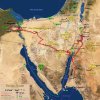
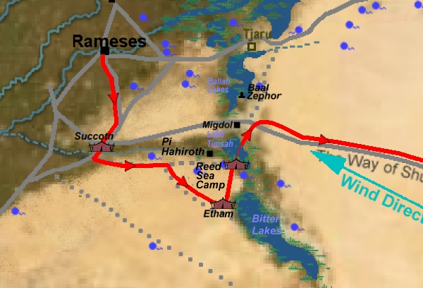
Click Image to Enlarge Topographical map of crossing area. |
|
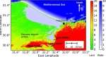
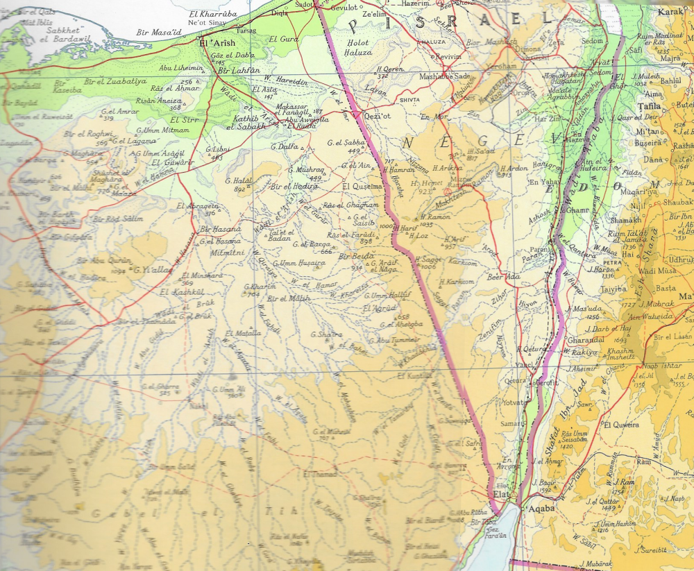
Click Image to Enlarge Exodus Route of Moses |
|
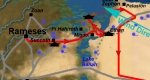
Click Image to Enlarge Alternative Israelite Etham camp and crossing scenario. |

|
I'm going to look at this story as if it were a military operation. Determination of the Exodus Route is not only a geographical problem and an archaeological problem. It is also a logistics problem. I'm not going to cover the original source of the story just it's possible planning and operation. Moses grew up in a royal household but was never a prince nor a general but was probably educated along side their children. If Moses had a plan on freeing the Israelites he would want to free them to a place. Going directly to Canaan would not be a good idea if a high number of them were women and children. He would need a safe location to bring the people and not into a potential war zone. The only place he had was Midian. Moses needs two things to move a great number of people to Midian. He needs roads and he needs fresh water. The map shows the route that maximizes both. Moses may have made several scouting trips to the Sinai Peninsula to locate watering holes and gauge road walking times. (My map marks the location where springs are currently. 3500 years earlier the campsites may match many spring locations, but the climate was wetter then so there may have been more of them.) Midian lies in the northwest corner of the Arabian Peninsula along the Gulf of Aqaba. A caravan trail would of run through it. The caravan would of carried things like frankincense (olibamum) and myrrh for pagan religious ceremonies. A major religious site was located at Kadesh (Petra) where pilgrims travel from all over the Middle East. Other goods from Arabia and Ethiopia may have been unloaded in Midian and in ports to the south and trans-shipped to the Levant region in order to avoid taxation at the Egyptian port of Ezion Geber at the north end of the Sea of Aqaba. Thus Moses made his way to Egypt. The Israelites were allowed to go. They set out from Pi-Rameses (Avaris) in divisions. That may mean they were organized in groups or echelons. Maybe fighting age males took up the rear and front positions as to guard the women and children in the center. Or, each tribe went separately. The first stop was Succoth. Genesis 33:17 Jacob, however, went to Succoth, where he built a place for himself and made shelters for his livestock. That is why the place is called Succoth [1]. The whereabouts is unknown but one old map marks a Jewish town location. Maybe we can assume the Israelites are going there first to gather (in tents) in large numbers outside of Avaris. We see Succoth is considered to be out of Egypt. Ex 12:37 The Israelites journeyed from Pi-Rameses to Succoth. There were about six hundred thousand men on foot, besides women and children. 12:39 With the dough the Israelites had brought from Egypt, Ex 12:41 At the end of the 430 years, to the very day, all the Lord's divisions left Egypt. It should be noted the borders of Egypt do not extend to some line on a map like modern national borders. Nor, to some future border like the Brook of Egypt. During Ptolemy's time an Egyptian priest when asked where does Egypt extend said that it is where the waters of the Nile cover. In addition Egypt was the 'black' land referring to the rich black soil. Our word "desert" is derived from the Egyptian word "dshrt", the red place, meaning place of red earth or sand. But the desert is not Egypt. Then they go to the next campsite. Ex 13:18 So God led the people around by the desert road toward the Reed Sea. (In the Ancient Hebrew language "Yam Suph" can mean "Red Sea" but also can mean "Reed Sea" [2] .) The next camp site is called Etham. That is on the edge of the desert or wilderness. Indeed 'Etham' means the 'edge'. The Israelites go by road to get there. There are three plausible possible places for this. Link to similar ideas of Reed Sea Crossing 1. Along the Way of Shur road (desert road) over the bog near Lake Timsah in the desert known as El-Tih. Actually, the central plateau and mountain range of the Sinai peninsula were named El-Tih. 2. Along the Way of the Philistines road (not a desert road). South of Lake Menzaleh (Lake Tanis) at the end of the defensive fortified line/wall or 'shur' of Egypt eastern border. 3. Along the sink or serbonian[3] bog which will be someday be known as the Great Bitter Lake. (Possible desert trail to this spot.) Link to somewhat similar crossing idea. The next camp is described as being in the desert near the Reed Sea closer to Pi-Rameses. Thus they have to back track to a degree. This in order to confuse or entice the Egyptians into attacking them. I don't know why they wanted to encourage that but maybe the Israelite army intended to ambush the Egyptian chariots from the reed bog. This camp could be only a rear guard which was to delay the Egyptians allowing the other Israelites to escape. The strong wind at the time may have laid down the reeds and exposed the Israelite ambush positions. For example Exodus 14:19 Then the angel of God, who had been traveling in front of Israel's army, withdrew and went behind them. The pillar of cloud also moved from in front and stood behind them, 20 coming between the armies of Egypt and Israel. It looks like it is just the army of Israel and not all the women, children and livestock that is at the Reed Sea Camp. Where is this camp by the sea or bog? (Note that lakes seem to have been called seas at this time.) It is said to be between Migdol and Pi Hahiroth. Mignol means tower or strong so that might be a border fort. Maybe guarding the Way of Shur or Way of the Philistine roads. Pi-Hahiroth means the house or place of a hollow or gorge. Though one translation says it means mouth of a gorge. The only terrain that resembles that in the area near the border is the Wadi Tumilat. This is a gully that extends from the Nile river to Lake Timsah. So Pi Hahiroth would be at the wadi's end or mouth. Long before Moses' time when the Nile River flooded annually water would flow down this wadi into Lake Timsah and the Bitter Lake bog, both are below sea level. These regions would eventu |
|
ally dry out when the Nile flooding ended. (Lake Timsah was also called crocodile lake because when it flooded crocodiles would make their way into the lake and then be unable to return to the Nile so it would act like a Roach Motel but for crocodiles.) Egyptian crocodile lake As late as 1850 BC a canal was dug down the wadi which diverted Nile water into Lake Timsah and the Bitter Lake sink. This acted to alleviate excess flooding that would destroy the crops. One other reference point is the location of Baal Zephron. The Israelite |
|
camp was suppose to be across from this. This may be a city or temple dedicated to Baal or it may just be Lake Ballah. Instead of ambushing the Egyptian chariots the seas parted and the Israelite army decided the better part of valor is |
|
to run across the open sea bottom. When the Israelite army got to the other side instead of going around to the far side by back tracking to a road the Egyptians decided to follow across the sea floor. This proved fatal as the wind that was holding back the water ceased and the waters rushed back like a tsunami drowning most. It is believed a natural phenomenon could explain this. It is called wind setdown. A strong steady wind can push the mass of a body of water to one end draining the other end. In 1882 Major General Tulloch of the British Army observed that Lake Menzaleh (Lake |
|
Tanis) (the possible Reed Sea) had it's bottom revealed as the waters were driven back by a strong wind. It was noted that other lakes in the area experienced the same. It is unusual that the wind is from the east, though from the south-east is more common. Hot winds, in Egypt known as Khamsin that blows across the country from the south or southeast in late winter or early spring. These hot winds usually arrive in April, but occasionally occur in March and May. Unobstructed by geographical features, these winds reach high velocities and carry great quantities of sand and dust from the desert. They are also known as 'Winds of fifty days' because they most commonly prevail during the fifty days preceding and following the vernal equinox. Link Going back to the scenarios: #1 Lake Ballah would have it's eastern or south-eastern side open as the water would be blown west. If the camp were to the southwest of the lake is illustrated in the main map. The Israelites have no way of escape but cross the lake or bog if attacked from the west. If the Israelites were to get across the lake the Egyptians would have to go back on the Way of Shur to catch them. Scenario 1 link #2 The Israelites would camp to the southwest of Lake Tanis and the wind would blow the waters west or north-west. (Note the map has been drawn as the lake existed at the time of Moses.) The lake was deeper than it is today. Today's current south-east shore was a sand bar in Moses' time. |
|
#3 This scenario would look like this: Scenario 3 link The Etham camp was in the desert near the Bitter Lakes, When ordered to go back they go toward Pi Hahiroth on the south-west shore of Lake Timsah instead of directly back towards Pi-Rameses. The map link is located to the right. Sinai Road Atlas The Bible says that Moses was told not to go along the coast road directly to Canaan so he would of gone by Way of the Shur or The Way of the King. It's too far to get to the The Way of the King road by just going south across the desert from the Lake Timsah area. |
|
Exodus 15:22 Then Moses led Israel from the Reed Sea and they went into the Desert of Shur. For three days they traveled in the desert without finding water. Exodus 15:23 When they came to Marah, they could not drink its water because it was bitter. But, the Desert of Shur is also called the desert of Etham. Numbers 33:8 They left Pi Hahiroth and passed through the sea into the desert, and when they had traveled for three days in the Desert of Etham, they camped at Marah. This would mean they camped on the fourth day. This proves that the Reed Sea crossing was before coming to the Wilderness of Shur/Etham, not some place along the Gulf of Aqaba/Red Sea (Greek:erythra thalassa) many miles to the east. There is a spring there, Bir al Jifjafah (Bir Gifgaffa), and it can be found with Mapcarta at [30.4506° N, 33.1956° E]. Seen on the map are some secondary roads leading south to The Way of the King from where the Marah camp is placed. They may be military roads build in modern times or built by the occupiers of Egypt over the centuries but they could be taken by travelers going directly toward Pi-Rameses. Modern Nekhel is most likely the Exodus Elim. It has many wells and trees and it sits next to the El Tih mountains where there are springs. The next point of reference comes from joining Numbers 33:10 They left Elim* and camped by the Red Sea with Exodus 16:1 The whole Israelite community set out from Elim and came to the Desert of Sin[4] ,which is between Elim and Sinai with Nu. 11:3 So that place was called Taberah. Nu. 33 list will combine one or more camps together. Look closely where I placed this. It is at a sea shore town called Taba. Midian is not very far away. Just get back on the The Way of King and head east, Unfortunately Ezion Geber and Egyptian patrols bar the way. Moses would have to detour around them. Further indications are Nu 11:34 Kibroth Hattaavah means Graves of Craving. More detail was added in DT 9:22 You also made the Lord angry at Taberah, at Massah and at Kibroth Hattaavah. So between Taberah and Kibroth Hattaavah there may have been another camp. (Usually Moses doesn't get camps listed out of order.) What is helpful in locating this is that there are springs at these locations. Later in DT 1:1 .opposite the Dead Sea...Hazeroth and Dizahab [5]. DT 1:2 (It takes eleven days to go from Horeb to Kadesh Barnea by the Mount Seir road. At this point I'm going to deviate from the narrative of Num 11:35. Moses should turn south after Kibroth Hattaavah yet the narrative of Num 11 has him continue north to Hazeroth. This is an illogical move and maybe an editor of the Torah added Exodus 11:35 From Kibroth Hattaavah the people traveled to Hazeroth and stayed there. to harmonize with Num 33:18. Thinking that there are two quail events when there is only one. . Once Moses turns south it is a clear trek to Midian. Other camp spots are mostly guesses. Dophkah may be a camp along the coast. Many Egyptologists are fond of toponyms. This may be the equivalent of Emerald Bay but in Egyptian for 'inlet light blue' or D-jr Mofka(t) = Dofkah. Alush might be near the fork in the road to Qurayyah. The last problem is the placing Rephidim. Ex. 19:1 On the first day of the third month after the Israelites left Egypt--on that very day--they came to the Desert of Sinai. 19:2 After they set out from Rephidim, they entered the Desert of Sinai, and Israel camped there in the desert in front of the mountain. So maybe close to the mountain? It may be closer to Mt. Horeb than I show but the Israelites did not have any water there. You would think Moses would of known where the springs were located so close to home. The maps all show where springs currently are. Springs in Midian Where did Moses finally camp at? Most likely at Jebel al-Lwaz. But, Jethro probably lived far from Horeb. Most likely Qurayyah east of Horeb. This was a town that produced a lot of copper products. If Moses was going to cast his 100 plus talents of silver into Tabernacle post footing he would have to ship it there. Copper processing PDF Besides copper working Qurayyah was a major pottery producer. Link PDF The pottery has been found in Timna and in towns in the Negev and southern Canaan, It has been proposed that Qurayyah was the capital of Midian. Some may doubt that the Red Sea crossing was at one of the shallow freshwater lakes. They may scoff at the Egyptians being drowned in only 6-8 feet of water. They thus argue it is impossible for God to knock soldiers off their feet and drown them in turbulent shallow water but he is fully capable to part and hold back 2200 feet of sea water with a strong wind blowing parallel to the wall of water. [1] Succoth means shelters. [2] Suph means reeds but in the middle Hebrew it can mean edge, Just not in early Hebrew. [3] An serbonian bog is a bog covered by blown sand such that it looks like dry land but is actually a bog or swamp. As an early theory was that the Israelites were on the other side of a serbonic bog and the Egyptians mistook it for land and drove their chariots into it drowning themselves. It's hard to see someone who lives where this happens to be fooled by this. [4] There in no other reference to a Wilderness of Sin anywhere. This may be a short form of Sinai. It may be the desert centered on Hashem El Tarif if that is Mt. Sin. [5] Wadi Faynan - Punon - A copper mining region. Though sometimes pockets of gold is found with copper ore. |
|
The Exodus After Action Report |